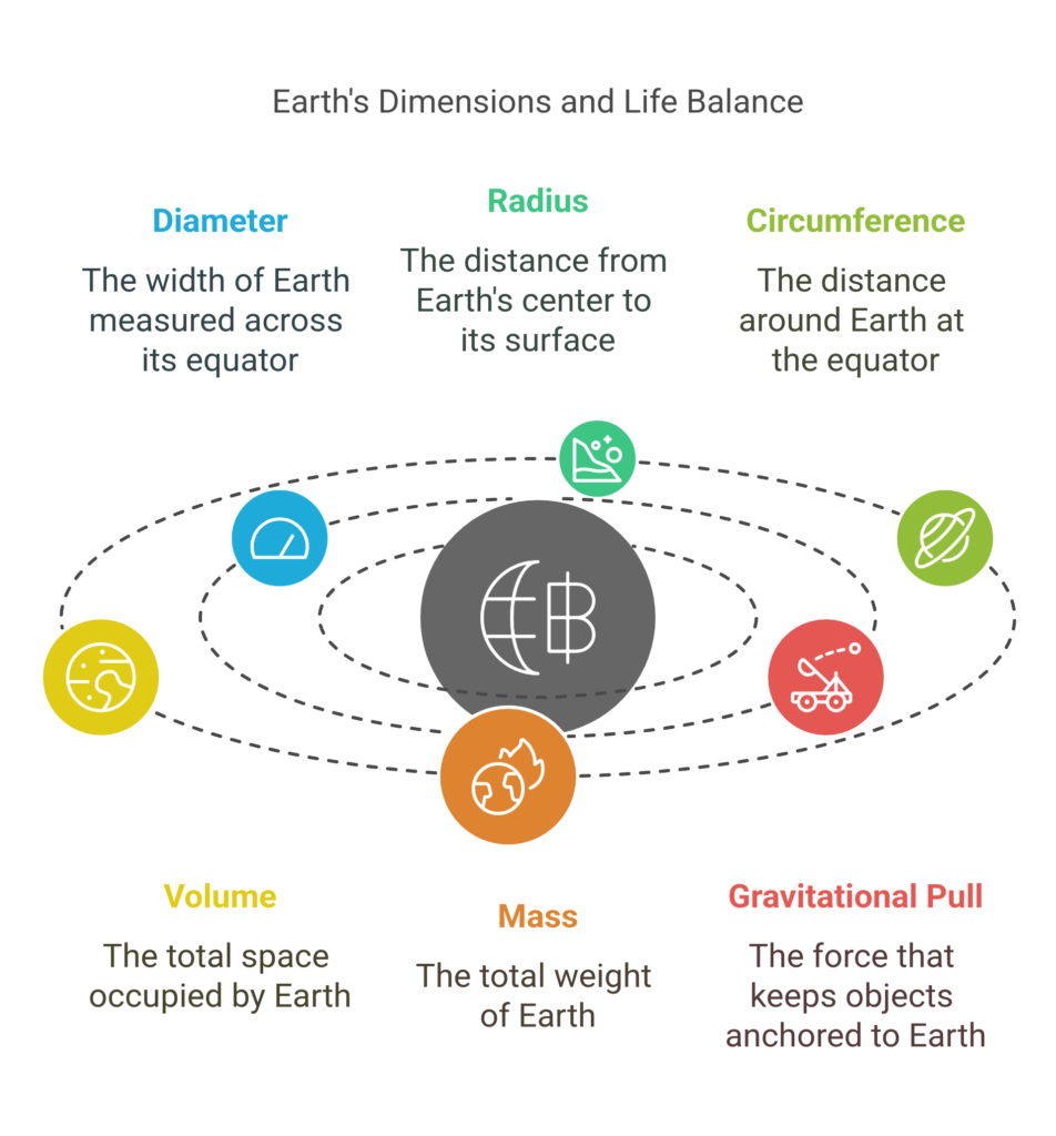
Discovering the true size of our home planet reveals an incredible story of scientific achievement and natural wonder. Our Earth’s dimensions tell us much more than just numbers – they help us understand everything from weather patterns to satellite orbits, and even our place in the vast cosmos.
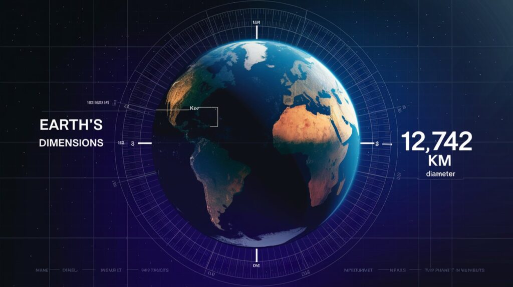
Earth’s Diameter and Radius: Fundamental Measurements
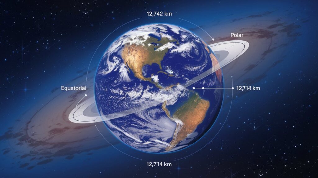
Our planet isn’t perfectly round – it’s actually an oblate spheroid, slightly flattened at the poles and bulging at the equator. The equatorial diameter measures 12,742 kilometers (7,918 miles), while the polar diameter spans 12,714 kilometers (7,926 miles). This 28-kilometer difference might seem small, but it significantly impacts everything from GPS technology to weather patterns.
Scientists measure these dimensions using a combination of satellite measurements and ground-based observations. Modern geodesy techniques have refined these measurements to unprecedented accuracy, helping us understand how Earth’s shape changes slightly due to factors like tidal forces and plate tectonics.
How Large is Earth? – Interactive Discussion
With John & Kapela
Earth’s Circumference Measurement
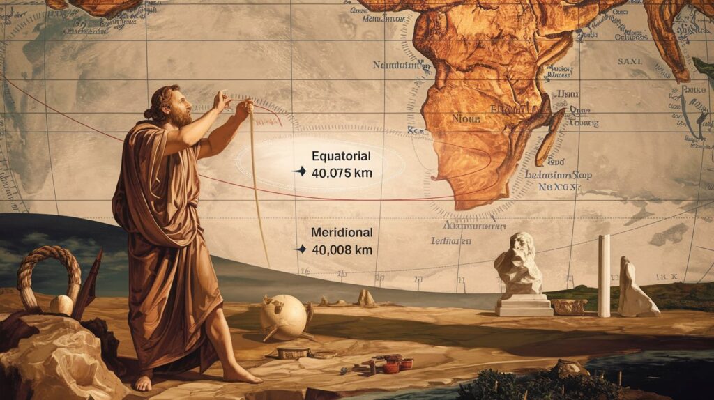
The story of measuring Earth’s circumference begins with the ancient Greek mathematician Eratosthenes in 240 BCE. Using shadows in Alexandria and Syene, he calculated Earth’s circumference with remarkable accuracy for his time. Today, we know the equatorial circumference (40,075 kilometers/24,901 miles) Earth’s equatorial circumference measurement , while the meridional circumference measures 40,008 kilometers (24,860 miles).
Must Explore :
Earth Measurement Methods
Modern scientific calculations combine various technologies to measure our planet precisely. GIS (Geographic Information Systems) and advanced satellite measurements provide detailed data about Earth’s dimensions. These tools help scientists track even tiny changes in Earth’s shape caused by earthquakes, ocean currents, and atmospheric pressure variations.
Earth’s Surface Area: A Global Overview
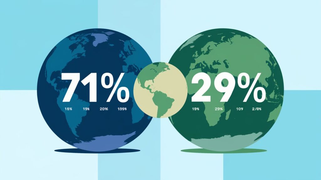
The total planetary surface covers an impressive 510 million square kilometers (197 million square miles). Ocean coverage dominates at 71%, with the remaining 29% being land area. This distribution plays a crucial role in Earth’s climate systems and supports diverse marine ecosystems.
| Continent | Area (km²) | % of Earth’s Land |
|---|---|---|
|
Asia
|
44,579,000 | 30.0% |
|
Africa
|
30,370,000 | 20.4% |
|
North America
|
24,709,000 | 16.6% |
|
South America
|
17,840,000 | 12.0% |
|
Antarctica
|
14,200,000 | 9.5% |
|
Europe
|
10,180,000 | 6.8% |
|
Australia
|
7,692,000 | 5.2% |
|
Greenland
|
2,166,086 | 1.4% |
|
New Guinea
|
785,753 | 0.5% |
|
Borneo
|
748,168 | 0.4% |
Earth’s Volume and Mass: How They Are Measured
Understanding Earth’s volume and mass helps scientists study everything from core composition to gravitational force. These measurements come from combining surface observations with data about Earth’s internal structure, gathered through seismic monitoring and gravitational studies.
Volume: 1 Trillion Cubic Kilometers (260 Billion Cubic Miles)
The Earth’s massive volume provides space for its complex internal structure, including the core, mantle, and crust. This volume isn’t static – it changes slightly due to tectonic activity and other geological processes.
Mass: 5.97 × 10²⁴ kg
Earth’s planetary mass determines its gravitational force and influences everything from ocean tides to atmospheric retention. This incredible mass results from billions of years of planetary formation and accumulation.
Earth Dimensions Unit Converter
Gravitational Pull and Earth’s Density
Earth’s average density of 5.51 g/cm³ and surface gravity of 9.8 m/s² create the perfect conditions for life as we know it. The gravitational force varies slightly across Earth’s surface due to differences in local density and elevation.
Must Visit :
The Vastness of Earth’s Oceans
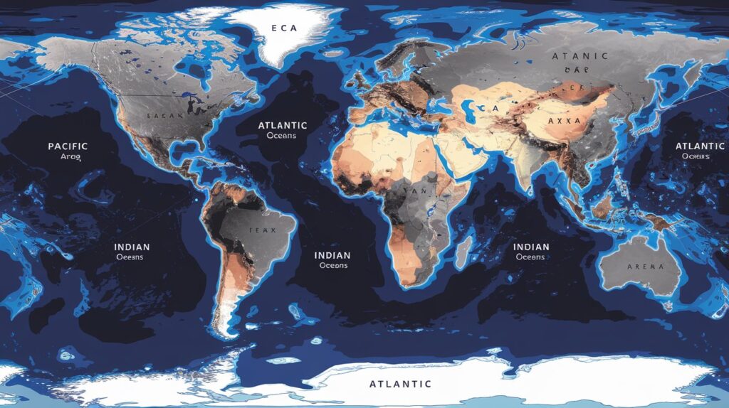
The oceans define Earth’s character as a blue planet. Let’s explore the largest bodies of water that dominate our planet’s surface.
🌊 World’s Oceans: Stats & Figures 🌊
| Ocean Region | Surface Area (km²) | Average Depth (m) |
|---|---|---|
| Pacific Ocean | 165,250,000 | 4,000 |
| Atlantic Ocean | 106,460,000 | 3,646 |
| Indian Ocean | 73,556,000 | 3,741 |
| Southern Ocean | 20,327,000 | 4,000 |
| Arctic Ocean | 14,056,000 | 1,205 |
| Philippine Sea | 5,695,000 | 5,559 |
| Coral Sea | 4,791,000 | 2,394 |
| Arabian Sea | 3,862,000 | 2,734 |
| South China Sea | 3,500,000 | 1,000 |
| Caribbean Sea | 2,754,000 | 2,200 |
Pacific Ocean
The Pacific OceanThe Pacific Ocean covers nearly one-third of Earth’s surface, containing more water than all continents combined. Its depth reaches its maximum at the Mariana Trench. covers nearly one-third of Earth’s surface, containing more water than all continents combined. Its depth reaches its maximum at the Mariana Trench, showcasing the tremendous scale of Earth’s ocean basins.
Atlantic Ocean
The Atlantic OceanThe Atlantic Ocean plays a crucial role in global climate through currents like the Gulf Stream. It influences weather patterns across Europe and the Americas., though smaller than the Pacific, plays a crucial role in global climate through currents like the Gulf Stream. It influences weather patterns across Europe and the Americas.
Indian Ocean
The Indian Ocean The Indian Ocean profoundly affects climate patterns through phenomena like monsoons and El Niño/La Niña events, particularly impacting South Asia and surrounding regions. profoundly affects climate patterns through phenomena like monsoons.
How Earth Compares to Other Planets

Our planet’s size perfectly balances the needs of life, placing it in a unique position among its solar system siblings.
| Planet | Diameter (km) | Mass (kg) |
|---|---|---|
| Mercury | 4,879 | 3.285 × 10²³ |
| Venus | 12,104 | 4.867 × 10²⁴ |
| Earth | 12,742 | 5.97 × 10²⁴ |
| Mars | 6,779 | 6.39 × 10²³ |
| Jupiter | 139,820 | 1.898 × 10²⁷ |
| Saturn | 116,460 | 5.683 × 10²⁶ |
| Uranus | 50,724 | 8.681 × 10²⁵ |
| Neptune | 49,244 | 1.024 × 10²⁶ |
| Pluto | 2,377 | 1.303 × 10²² |
| Ceres | 940 | 9.393 × 10²⁰ |
Size Comparison with Terrestrial Planets
Earth dwarfs Mercury but is smaller than Venus, though similar in size. Mars is roughly half Earth’s diameter, highlighting our planet’s optimal size for maintaining its life-supporting atmosphere.
Earth vs. Gas Giants
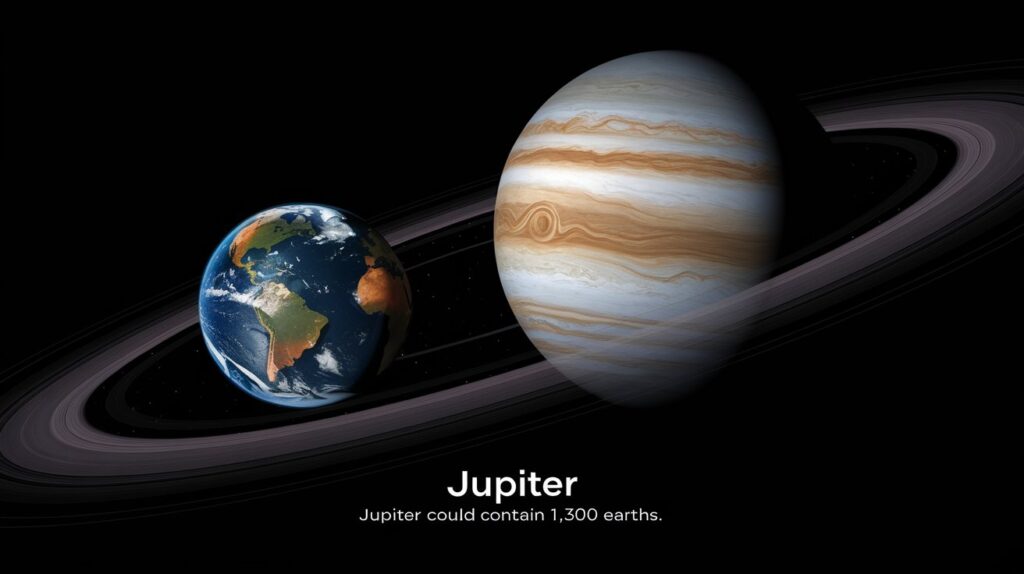
The massive gas giants – Jupiter, Saturn, Uranus, and Neptune – make Earth seem tiny in comparison. Jupiter alone could contain more than 1,300 Earths, yet our planet’s size makes it perfect for supporting life.
Check this out :
Earth’s Dynamic Nature
The planet’s dimensions aren’t static – they’re constantly changing due to geological processes. Geophysics research shows how earthquakes, volcanic activity, and plate tectonics continuously reshape our world.
Global Climate Implications
Earth’s size and shape significantly influence global weather patterns. Meteorology experts study how these dimensions affect atmospheric circulation and climate systems worldwide.
Space Exploration Perspective
Aerospace engineering relies heavily on precise knowledge of Earth’s dimensions for calculating orbital mechanics and planning space missions. This understanding has revolutionized our ability to explore beyond our planet.
Technological Applications
Modern technology depends on accurate measurements of Earth’s dimensions. From GPS satellites to telecommunications, these measurements ensure the proper functioning of many systems we use daily.
Earth’s Dynamic Morphology
The shape of our planet constantly undergoes subtle changes due to various natural forces. Tidal forces from the Moon and Sun gently pull and stretch Earth’s surface, creating daily bulges that move across the globe. Meanwhile, tectonic activity continually reshapes continents and ocean floors, altering Earth’s dimensions on a geological timescale.
Seasonal changes also affect Earth’s dimensions. The redistribution of water through the annual cycle of melting and freezing at the poles causes measurable variations in Earth’s shape. Even groundwater depletion and glacier melting contribute to these ongoing dimensional shifts.
Earth’s Internal Structure and Its Impact on Size
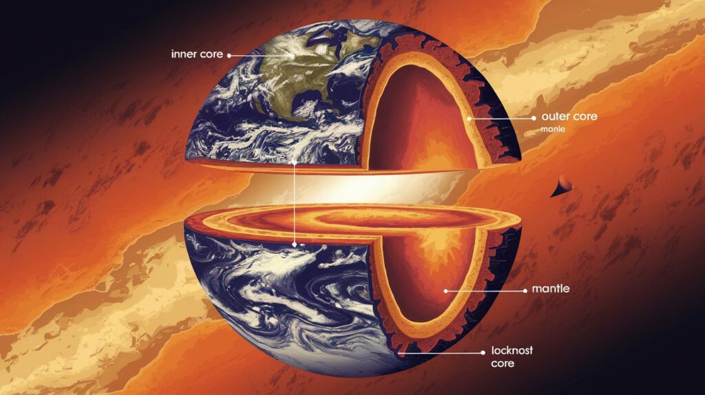
Our planet’s layered internal structure plays a crucial role in maintaining its dimensions. The hot, dense inner core measures approximately 1,516 kilometers (942 miles) in radius, while the liquid outer core extends to about 3,486 kilometers (2,166 miles) from Earth’s center. The mantle and crust complete this complex arrangement, each layer contributing to Earth’s overall size and stability.
| Layer | Depth (km) | Temperature (°C) |
|---|---|---|
| Upper Crust | 0-35 | 20-870 |
| Lower Crust | 35-70 | 870-1,600 |
| Upper Mantle | 70-700 | 1,600-2,200 |
| Transition Zone | 700-2,890 | 2,200-2,900 |
| Lower Mantle | 2,890-5,150 | 2,900-4,000 |
| Outer Core | 5,150-6,370 | 4,000-5,400 |
| Inner Core Boundary | 6,370-6,371 | 5,400-5,500 |
| Inner Core | 6,371-6,400 | 5,500-6,100 |
| Core Center | 6,400 | 6,100 |
| D” Layer | 2,700-2,890 | 2,800-3,000 |
Regional Variations in Earth’s Surface
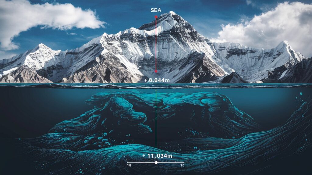
The planet’s surface isn’t uniform in elevation. The highest point, Mount Everest, reaches 8,848 meters (29,029 feet) above sea level, while the deepest point in the Mariana Trench plunges to 11,034 meters (36,201 feet) below sea level. These extreme variations demonstrate the dynamic range of Earth’s surface features.
Also Like To Know This :
Impact of Human Activities on Earth’s Dimensions
While subtle, human activities can affect Earth’s measurements. Major construction projects, mining operations, and reservoir creation cause measurable changes in local gravity fields and surface elevation. The Three Gorges Dam in China, for example, holds enough water to alter Earth’s rotation speed by a fraction of a microsecond.
Earth’s Unique Position in the “Goldilocks Zone”
Our planet’s size directly contributes to its position in the habitable or “Goldilocks Zone” of our solar system. This perfect sizing allows Earth to:
FEATURE
- Atmospheric Retention
- Surface Gravity
- Magnetic Field Strength
- Tectonic Activity
IMPACT ON HABITABILITY
- Just right to hold essential gases
- Ideal for liquid water existence
- Sufficient to protect from solar radiation
- Balanced for mineral cycling
Historical Methods of Earth Measurement
Before modern satellite measurements, various civilizations developed ingenious methods to measure Earth’s dimensions:
Ancient Chinese astronomers used well depths and shadow measurements. Medieval Islamic scholars refined Greek calculations using desert caravans. 18th-century French expeditions measured latitude arcs to determine Earth’s shape.
| Time Period | Method Used | Accuracy (km) |
|---|---|---|
| 240 BCE | Eratosthenes’ Shadow Method | ±500 |
| 827 CE | Al-Ma’mun’s Desert Measurement | ±400 |
| 1525 | Fernel’s Degree Measurement | ±350 |
| 1669 | Picard’s Triangulation | ±100 |
| 1735 | French Geodesic Mission | ±50 |
| 1880 | Clarke’s Calculations | ±10 |
| 1924 | International Spheroid | ±5 |
| 1960 | Satellite Geodesy | ±2 |
| 1984 | WGS84 System | ±0.1 |
| 2020 | Modern GPS/GNSS | ±0.001 |
Applications in Modern Technology
Understanding Earth’s exact dimensions is crucial for:
Satellite Navigation Systems
Modern GPS technology requires incredibly precise measurements of Earth’s shape for accurate positioning. Even tiny errors in these calculations could result in significant navigation mistakes.
Climate Modeling
Global climate models rely on detailed knowledge of Earth’s dimensions to simulate atmospheric and oceanic circulation patterns accurately. This understanding helps predict weather patterns and long-term climate trends.
Conclusion
Earth’s dimensions represent more than just measurements – they reveal the delicate balance that makes our planet uniquely suitable for life. Understanding these dimensions helps us appreciate our place in the cosmos and the importance of preserving our planetary home.
Frequently Asked Questions
Also like to read this :

John Smith and Kapela Rodriguez, engineering experts and creators of Measured Inches, transform complex measurements into simple, everyday examples. As mechanical and civil engineers, they combine their technical expertise to help readers visualize different units through practical comparisons. Their clear approach has made Measured Inches a trusted resource for understanding measurements.


This article is packed with great information and is very helpful.
The website is an excellent resource for learning.
Wow that was unusual. I just wrote an extremely long comment but
after I clicked submit my comment didn’t appear.
Grrrr… well I’m not writing all that over again. Regardless, just wanted to say fantastic blog!
Very good article! We will be linking to this particularly great post on our site.
Keep up the great writing.